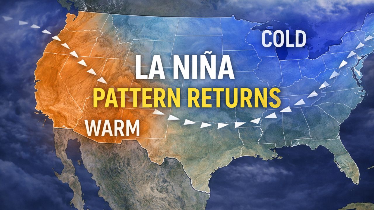
Washington, D.C. — After a brief break to start the new year, the La Niña winter pattern is expected to make a comeback later this month, setting the stage for a warmer West and colder, snow-prone conditions across the Northern Tier and parts of the East, according to long-range forecast guidance.
Weather experts say the recent pause in La Niña influence allowed a short-lived January warmup east of the Rockies. That break, however, is not expected to last much longer.
La Niña influence expected to reassert itself
Since early January, the dominant La Niña setup that shaped much of the winter temporarily weakened, allowing milder air to spread across portions of the central and eastern United States. Long-range models now indicate a return to more typical La Niña conditions by mid to late January.
This shift is expected to reshape weather patterns nationwide, especially as a strong ridge of high pressure builds over the eastern Pacific and moves inland across the western United States.
“Long-range forecast guidance points to a return of classic La Niña conditions as January progresses,” forecasters said.
West Coast likely to turn warmer and drier
As the ridge strengthens, much of the western U.S. is expected to see warmer-than-average temperatures and reduced precipitation.
This change may bring relief to areas that have seen repeated storms in recent weeks.
Read Also: New Pineapple Express Targets Washington, British Columbia, and Alaska With Flooding Risks
Key impacts expected in the West include:
- Drier conditions along the West Coast
- Above-average temperatures
- Jet stream shifting northward
Southern California, which has experienced rounds of heavy and in some cases record-breaking rainfall, is forecast to get a much-needed break. The ridge of high pressure is expected to suppress storm activity through at least next week, possibly longer.
The Pacific Northwest could also see a slowdown in precipitation. Oregon and Washington, both impacted by river flooding following December atmospheric river events, are forecast to trend drier under the returning La Niña pattern.
Northern Tier and East face colder outlook
While the West warms up, the opposite trend is expected across much of the Northern Plains, Upper Midwest, and Northeast.
As the ridge builds in the West, the jet stream is forecast to dip south from Canada into the eastern U.S., opening the door for colder air to push into the region.
“Below-average temperatures are expected across the Upper Midwest and Northeast by mid to late January,” forecasters noted.
This setup mirrors the weather pattern seen in December, when colder air dominated the northern half of the country while the West stayed unusually warm.
Snow chances increase for the Northeast
The return of colder air could be welcome news for winter sports enthusiasts. With La Niña conditions reestablishing themselves, snow potential increases across the Northeast, especially as a more active storm track becomes possible.
Why snow chances may improve:
- Colder air moving south
- More frequent disturbances along the jet stream
- Higher likelihood of coastal or inland winter systems
Ski resorts across the Northeast could benefit if temperatures remain cold enough to support both natural snowfall and snowmaking.
Pattern reflects weak La Niña winter
Climatologists say the overall setup remains consistent with a weak La Niña winter in the equatorial Pacific. December already delivered a textbook La Niña pattern across the Lower 48, with record warmth in the West and cold, snowy conditions across the northern U.S.
That same pattern now appears poised to return.
Longer-range forecast models also hint at the possibility of a developing system along the East Coast as the pattern takes shape later in January.
The FOX Forecast Center cautions that forecast details could change, noting the uncertainty that comes with outlooks more than a week away.
What to expect heading deeper into January
While exact timing and storm specifics remain uncertain, the broader message from forecasters is clear:
- West: Warmer and drier trend likely
- Northern Tier: Colder temperatures returning
- Northeast: Increasing potential for snow events
As the La Niña pattern reasserts itself, weather conditions could shift quickly, making it important for residents to stay alert to forecast updates.
How do you feel about winter conditions possibly ramping back up later this month? Share your thoughts in the comments below.