Columbus, Ohio — The Ohio Valley is settling into a prolonged stretch of winter weather risk, with forecasters warning that persistent Arctic cold will keep the door open for additional snowstorms through mid-February. While no single storm is locked in yet, the broader pattern favors repeated winter impacts across Indiana, Ohio, Kentucky, and West Virginia in the days ahead.
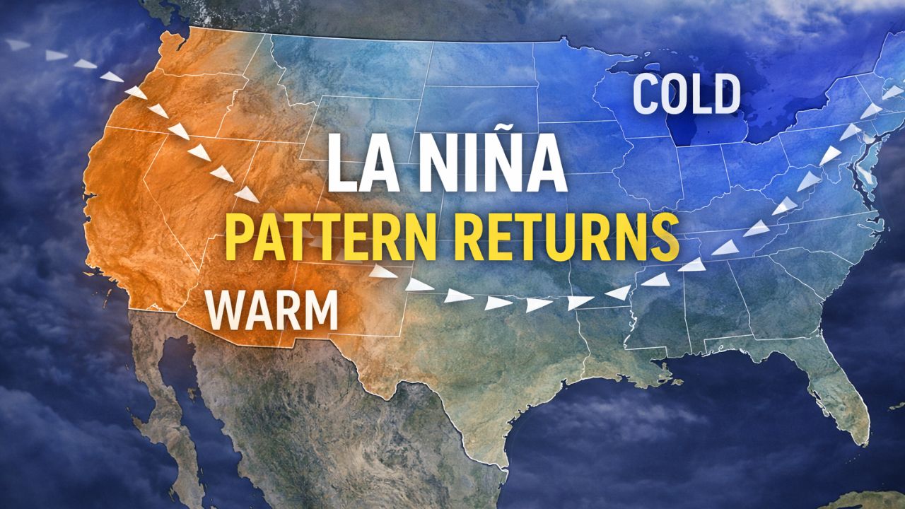
According to outlooks from the National Weather Service Climate Prediction Center, temperatures across the Ohio Valley are expected to remain below normal from February 7 through February 20. With cold air firmly entrenched, any storm system moving through the Midwest or Tennessee Valley would likely produce snow or mixed winter precipitation, rather than rain.
Meteorologists say this type of setup often leads to multiple rounds of winter weather, even if individual storms vary in strength and track.
Winter Storm Fern Sets the Stage
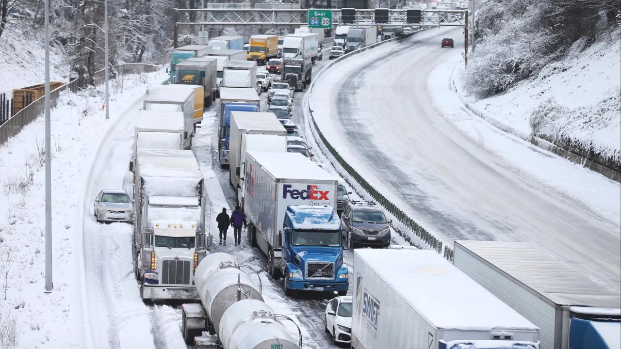
The heightened concern follows Winter Storm Fern, a sprawling system that swept from Texas to Maine and impacted more than two dozen states. Across the Ohio Valley, Fern delivered widespread snowfall, with many communities in Ohio, Indiana, Kentucky, and West Virginia reporting totals exceeding a foot.
Travel conditions deteriorated quickly as snow and gusty winds moved through the region.
Major corridors affected included:
- Interstate 64
- Interstate 65
- Interstate 70
- Interstate 71
- Interstate 75
- Interstate 77
School closures, supply disruptions, and scattered power outages were reported as the storm intensified. Even after the snow ended, lingering cold prevented melting, allowing snowpack and ice to persist.
Why the Snow Threat Isn’t Going Away
Forecasters emphasize that the current risk is not tied to a single storm, but to the overall atmospheric pattern.
Very cold Arctic air remains locked over much of the central and eastern United States. This means:
- Any new storm system is more likely to produce snow
- Snow that falls is less likely to melt between events
- Overnight refreezing becomes a recurring hazard
“When cold air doesn’t retreat, winter weather impacts tend to compound,” forecasters noted.
Longer-range models continue to support an active storm track capable of sending systems through the Midwest, Ohio Valley, and Mid-South over the next two weeks.
Read Also: Historic Winter Storm Timeline: What Different Regions Across the U.S. Can Expect Next
Areas Most at Risk Across the Ohio Valley
Communities from central and northern Indiana through Ohio, northern Kentucky, and West Virginia remain in the zone most likely to see renewed winter impacts.
Cities and regions of concern include:
- Central Ohio, including the Columbus metro area
- Northern and central Indiana
- Eastern Kentucky
- Much of West Virginia, especially higher elevations
Because temperatures are expected to stay below seasonal averages, even moderate snowfall could result in significant disruptions, particularly during peak travel hours.
Transportation Challenges Could Multiply
Transportation officials across the region warn that repeated snow events may strain resources as crews work to keep roads clear.
Persistent cold increases the risk of:
- Ice buildup on untreated roads
- Dangerous conditions on bridges and overpasses
- Reduced effectiveness of road treatments during extreme cold
Overnight and early morning hours are expected to remain especially hazardous, even on days without active snowfall.
Drivers are urged to closely monitor conditions, particularly during periods of refreezing when pavement may appear clear but remain slick.
Emergency Officials Urge Early Preparation
Emergency management agencies across the Ohio Valley are encouraging residents not to let their guard down simply because the last storm has passed.
Recommended preparation steps include:
- Checking heating systems and backup heat sources
- Restocking winter emergency supplies, including food and medications
- Preparing vehicles with winter tires, washer fluid, and emergency kits
- Planning for potential travel delays or school disruptions
Officials stress that preparation is easier now than during an active storm.
Uncertainty Remains, But the Signal Is Clear
Forecasters caution that specific storm timing and snowfall totals cannot yet be pinned down. Small shifts in storm tracks can lead to big differences in who sees the heaviest snow.
However, confidence is growing in the overall message:
Cold air is expected to remain in place, and winter threats are likely to continue.
As confidence increases, additional winter weather advisories or warnings may be issued across parts of the Ohio Valley.
Looking Ahead to Mid-February
While brief breaks in active weather are possible, the broader pattern suggests that winter will remain a recurring concern across the region through at least mid-February.
Residents are encouraged to stay weather-aware, monitor updated forecasts, and be prepared for the possibility of renewed snow and travel disruptions.
Do you think communities across the Ohio Valley are ready for another round of winter weather? Share what you’re seeing in your area and how you’re preparing in the comments below.